Land development projects alter the land’s associated natural water flows and the environments in which these flows discharge. Humans impact the land, and the land goes on to affect the water that, in turn, alters the land. Managing this cycle requires constant reevaluation and vigilance to understand the impact and identify the desired outcomes.
Land Development
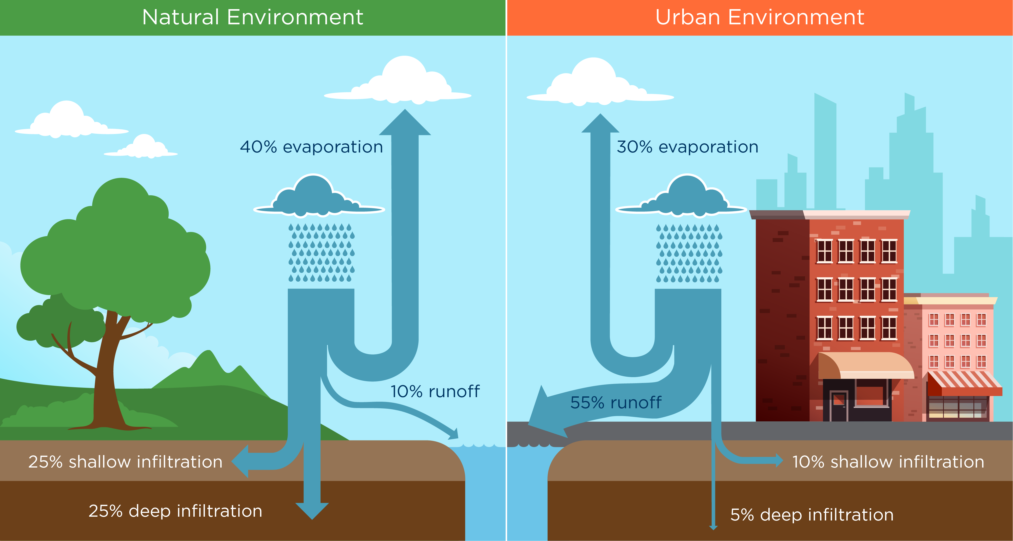
In urban environments, stormwater flows originate from snowmelt and rain and are designed to be channeled away over parking lots, concrete and other impervious surfaces. Any land development project must manage the rainfall runoff and control the flow’s impact downstream for both small and large storms.
Whether land improvement is from a greenfield or redevelopment project, the land parcel is typically stripped before the building phase begins. There are other construction options, but developers and contractors look for a clean slate where they can build most efficiently. The land will change, and although design criteria for new projects strive to mimic the previous environment, it is often not achievable.
Land development has many positive outcomes for societies and communities, and if we plan and develop carefully, it can have a positive impact on the natural processes and the land as well. Below is a rundown of the process.
Project Teams
The land development process typically involves a development team and a city and/or agency process team.
The development team focuses on surveying, engineering and constructing the project for the land owner. City teams focus on enforcing planning, public works and public safety criteria that must be met according to the community’s regulations. Both teams steer development projects through ordinances, design criteria and permits.
Every land development project has an established a set of goals and requirements. The developer and city process teams work toward meeting these defined expectations to meet the desired development and the corresponding regulations.
Planning Review
Land development projects often start with a planning review where a plat is overlaid on the site and changes to the land become evident. This is the first glimpse of what the changes to the land would be.
This review helps to identify existing flood plains, detention requirements, easements and land access. While the natural systems that moved the water flow in the past will be seen with an overlay of proposed changes, there often needs to be more consideration of stormwater at this stage.
Permitting
At this stage, engineers submit plans for transportation, stormwater and other public improvements. Overland flow paths identify the existing natural water flows on the site. Next, an overlay of buildings, structures and impervious areas is introduced. It becomes apparent how humans will alter and control the water flow with this new land use.
Stormwater management techniques for developed land can include enclosing overland flow paths, developing detention and retention facilities, and identifying storage options, vaults and more. However, the focus is often on how the developed land will be used, not on how rainfall runoff can be generated and used by the land.
At this stage, the goal is to get the necessary permits so the project can get underway.