At the Port of Port Arthur in southeast Texas, clarity mattered early. The port is in growth mode driven by the reshoring of manufacturing, a booming local economy and federal executive orders to strengthen America’s maritime sector. In committing the largest capital investment in port history, officials needed a team that could quickly develop a project that would deliver a rapid return on investment. They turned to Burns & McDonnell and its progressive design-build delivery model — a first for the port — to deliver efficiency and flexibility. The approach also would help keep construction moving forward with minimal disruption to active cargo operations and logistics.
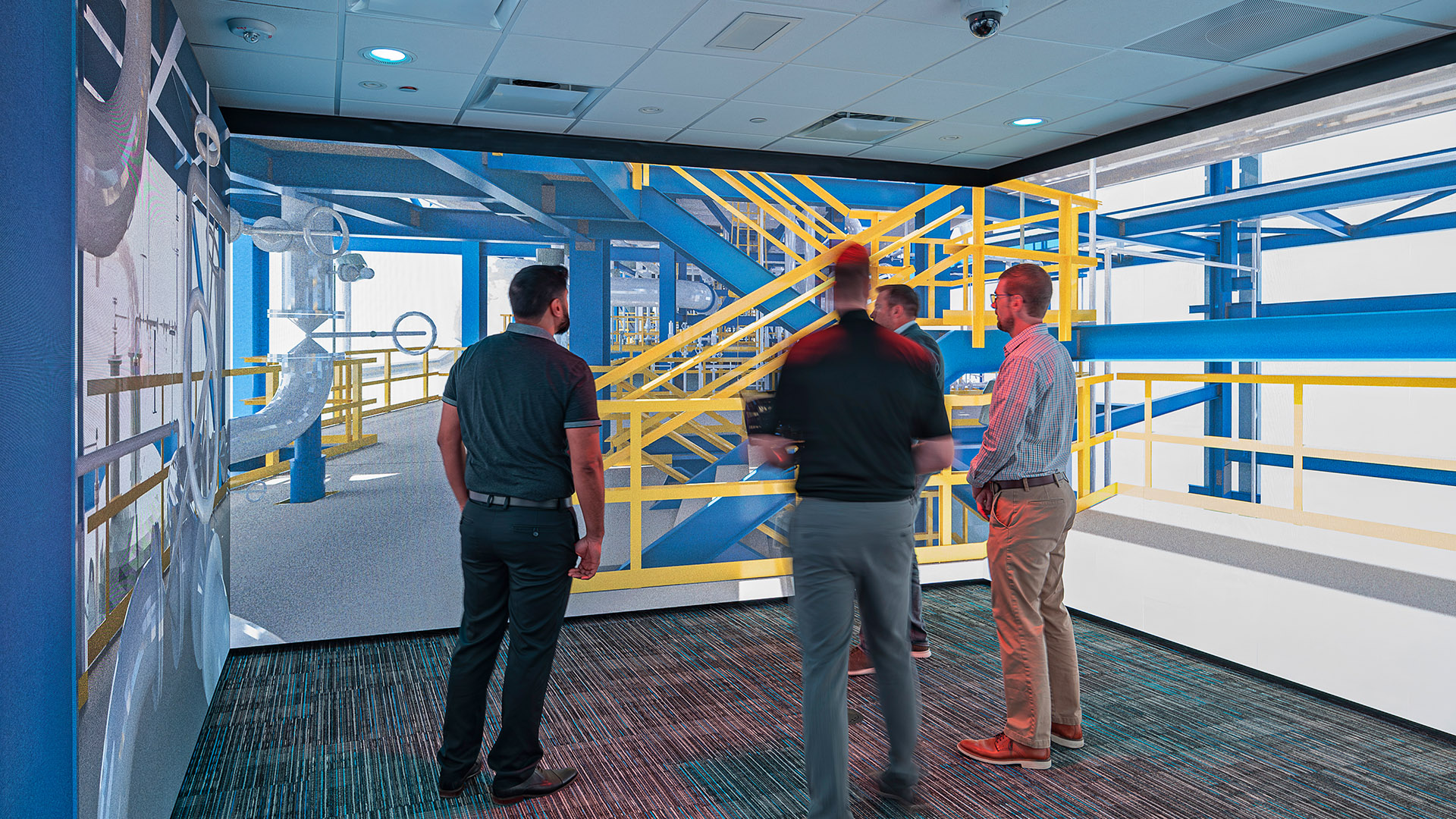
Rather than waiting until later design milestones, the project team introduced an immersive experience through a cave automatic virtual environment (CAVE), allowing users to step into a 360-degree, high-definition projection. This technology supports enhanced design reviews, virtual prototyping and immersive training experiences so that any assumptions from the project design could be tested and refined.
“This project was in a fully working environment,” says Andrew Reid, regional manager of the firm's Transportation Group in North Texas. “The port had to continue moving cargo while construction was underway. Being able to visualize phasing and access was critical to showing how operations would be maintained, inspiring confidence in our client regarding our delivery.”
By walking stakeholders through the project well before construction, conversations moved beyond drawings and into real-world implications. Phasing plans became easier to grasp and operational constraints could be evaluated visually. Questions which would typically surface during construction emerged during planning instead. This allowed changes and updates to be made in electronic documents rather than during concrete pours, equipment installations and other construction activities, saving both time and money.
How the project might affect nearby residences also could be explored virtually, ahead of time.
“Using our CAVE, we could show exactly what the structure would look like at night,” Reid says. “That allowed for a more informed discussion to happen about any design choices, so stakeholders felt confident in the decisions that were being made.”
Those same walkthroughs helped align expectations across technical and nontechnical audiences, from engineers and contractors to commissioners responsible for stewarding public funds.
“Being able to walk through the project in an immersive environment helped bring everyone along early, particularly our commissioners,” says Ed Long, engineering director at the Port of Port Arthur. “It’s been nothing short of a professional and positive experience working with a team that stays engaged and proactive.”
Incorporating technology early on also helped resolve design challenges before they became construction risks. Work needed to fit within a tight site constrained by active rail operations and long-term port development.
“One of the biggest challenges was fitting the bridge alignment between active rail lines while still meeting clearance requirements,” says Marcelo DaSilva, senior structural engineer. “Being able to see the alignment, the rail interfaces and future infrastructure together, made it much easier to explain why certain decisions had to be made.”
One of the decisions would cascade through the remainder of design: Establishing where a particular bridge bent would be placed, given that the bridge's alignment needed to thread the railyard's active tracks, including multiple rails diverging in a Y-shaped configuration. This location effectively set the alignment, grades and transitions on either side of the structure. Seeing that constraint spatially made it easier for all parties to understand why alternatives were limited and why certain tradeoffs were unavoidable.
“Visualization also extends beyond the immediate project footprint,” DaSilva says. “Future levy systems, railyard track expansion and potential port development were incorporated into the model, allowing stakeholders to see how today’s decisions would impact long-term plans. This broader context helped align expectations with both rail operators and community representatives.”
Immersive planning also changed who was in the room when critical conversations were happening. Instead of sequential handoffs between design and construction, the project team used the CAVE to bring those perspectives together at the same time. That approach proved especially valuable when discussing pile-driving activities near active operations and adjacent properties.
By visualizing construction sequencing alongside site conditions, teams could evaluate noise impacts and mitigation strategies collectively, allowing technical and communications considerations to be addressed in the same conversation sooner rather than later. Those discussions also surfaced potential safety challenges tied to tightly constrained work areas, construction around live high-voltage utilities and activity directly adjacent to non-local trucking operations. By identifying those conditions early and implementing mitigation strategies during planning, the team strengthened safety for the port, its customers and the project workforce.


.svg)


.svg)


.svg)

